- /
- Overview
- /
- 17. Appendix

Riverbank erosion and deposition are natural processes due to changes in the river flow. Prior to any disturbance from the river sand/stone mining operation, the state of a river is in equilibrium with its flow. The flow of a river is determined by its gradient (slope) and sections. Any extraction on the river will unavoidably alter the gradient and sections of the river thus disrupting the flow and current equilibrium resulting in changes to the riverbank erosion and deposition patterns. To minimise flow disturbance due to the aforementioned reason, the determination of extraction area for river sand/stone mining operations must strictly adhere to the DID’s excavation depth and middle third requirements. For visualisation, refer to the illustrations on the following page which depict the river flow when extraction within the middle third section of the river is complied with and when it is not. Mitigation measures to minimise the disruption of rivers due to sand/stone extraction is detailed in SOP 1 and 3.
.
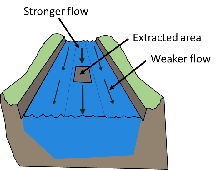
Within middle third
River flow disturbance is minimised, especially the flow direction is maintained hence erosion to the riverbank is significantly reduced.
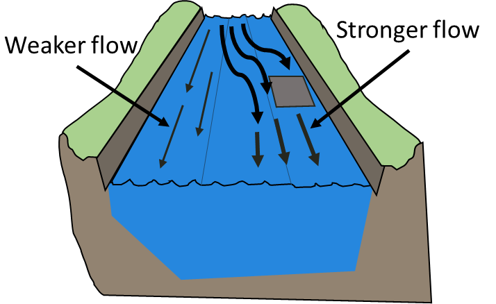
Outside of the middle third
River flow has been disturbed especially the flow direction resulting in new erosion and deposition patterns hence erosion of riverbank will significantly increase.

.
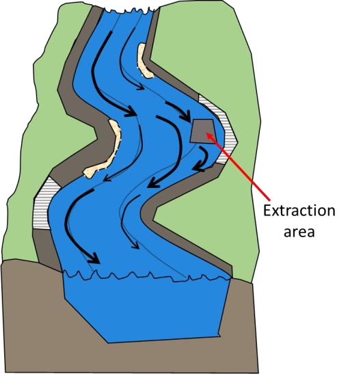
Within middle third
Disruption to river flow is minimised especially the flow direction hence the erosion and sedimentation pattern which causes the concave (bulging inward) and convex (bulging outward) of a river is maintained.
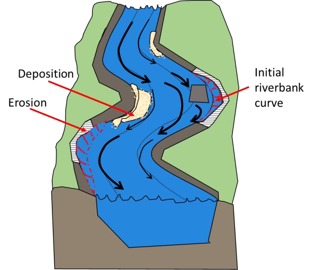
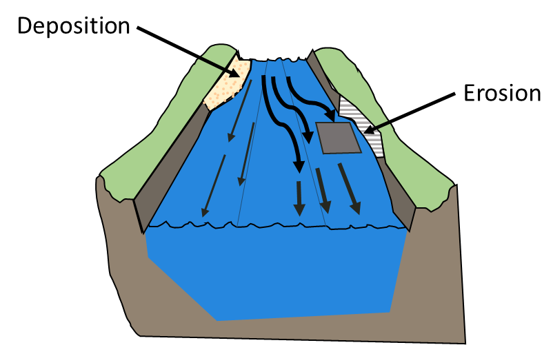
Outside of the middle third
Disruption of river flow especially the flow direction resulting in new erosion and deposition patterns, erosion of riverbank will significantly increase.
The natural state of a river is in equilibrium but may change due to natural causes such as high flood flows events or earthquakes and human activities. River sand and stone mining activities are one of the causes that changes the natural state of rivers by lowering the riverbed and accelerating riverbank erosion. Over extraction and extraction in prohibited areas of the river are the main causes of unacceptable changes to the riverbed and banks.
A) Riverbeds and Banks Monitoring
Monitoring changes in beds and banks of rivers due to sand and stone mining activities is a systematic and objective way to observe the physical changes of the river. Monitoring is to be carried out and analysed to detect changes for a stretch of river at fixed locations and intervals over a period of time.
The condition of the riverbed and banks of a particular stretch of river for mining will be identified by a survey during project prospecting or the EIA stage. The survey will provide a plan of the river, the longitudinal profile and cross-section at specific locations along the river. Typically, the survey includes stretches of river proposed for mining and 200 meters upstream and downstream of the mining area. This survey becomes the baseline for monitoring. Periodical resurveys of this stretch of river will provide a longitudinal profile and cross-sections at the same locations for comparison and to detect any changes. It is very important that the river longitudinal profile and cross-sections are closely monitored. When the allowable longitudinal profile and cross-sections have been reached, the mining activity shall be stopped. Any further excavation will cause unacceptable riverbank erosion and lowering of the river depth.
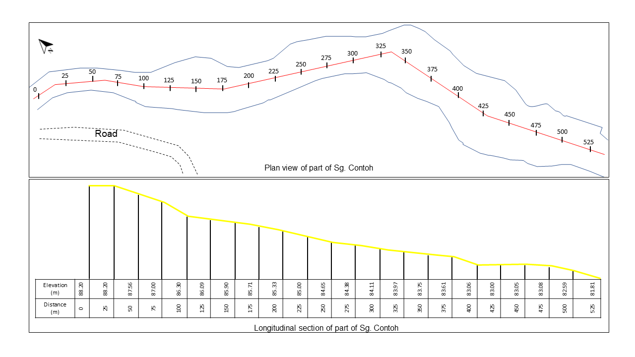
Illustration 1: Example of Plan View and Longitudinal Section of a River
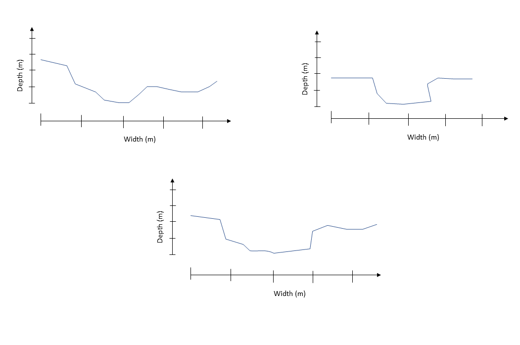
Illustration 2: Example of River Cross-section
In addition, a riverbank erosion indicator or marker can be installed at selected and fixed cross-section points according to the original survey to detect any changes to the riverbanks and to monitor riverbank changes. The markers are to be fixed at one (1) meter or more behind the top of banks or a certain convenient distance from the edge of the vegetation.

Illustration 3: Erection of riverbank erosion indicator or marker
Installation and record keeping of riverbank erosion indicator or marker are as follows:
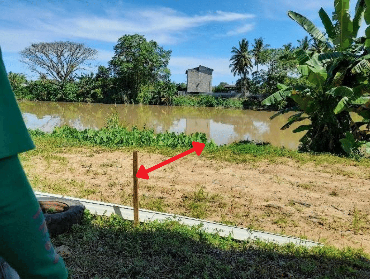
Plate 1: Distance between indicator or marker to the riverbank.
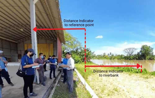
Plate 2: Measurement of reference point.
B) Determination of the edge of a riverbank
When monitoring the banks of a river as detailed in the previous section (a), measurements of the distance between the edge of the riverbank to the installed indicator or marker are necessary. Although it may appear simple on paper, conducting the activity on-site may be challenging for those who are inexperienced. A brief explanation of how to determine the edge of a riverbank is as follows.
As a general principle, the edge of a riverbank is determined by the first fall when the land is sloping downwards. Two (2) persons are required to utilise this method. The first person walks slowly towards the bank with closed eyes while the second person refrains the first person from falling into the river. When the first person senses the first fall, then he/she is considered to be standing at the edge of a riverbank. Refer to the plates and illustrations shown below.
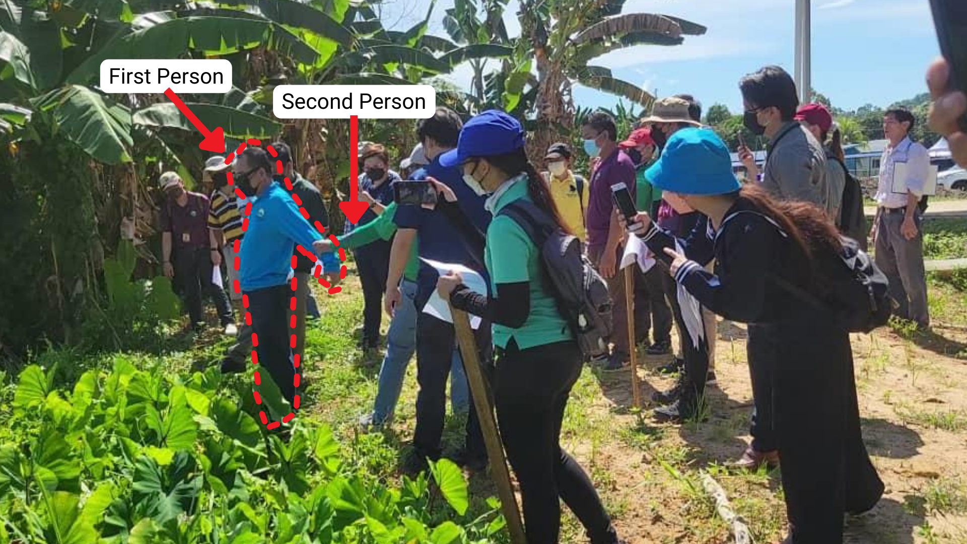
Plate 3: Man standing at the edge of the riverbank
Observe the man outlined in red. He is standing at the edge of a riverbank. The edge may not be visible due to vegetation. However, on-site, as one walks slowly towards the bank with eyes closed, one will be able to tell when one is at the edge the instance the land one steps on starts to slope downwards or one senses the first fall. The illustration shown on the next page depicts the position where the man is standing if vegetation is removed from the photo above.
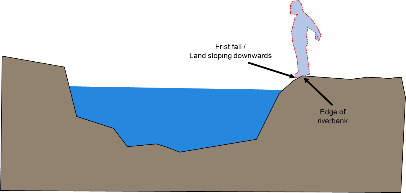
Illustration 4: Man standing at the edge of the riverbank
C) Riverbeds and Banks Monitoring Frequency
Monitoring of riverbeds and bank is proposed to be carried out every quarterly whereas observations of riverbank erosion indicators or markers can be carried out weekly or monthly. It is best to conduct observations of riverbanks after any high flow events.
C) Personnel for Riverbeds and Banks Monitoring
Proposed personnel to conduct riverbeds and banks monitoring is as follows: